Yashio Bridge – Crossing the Industrial Canal
Yashio Bridge (八潮橋) is a vital connection spanning the Keihin Canal in Shinagawa Ward, Tokyo. Completed around 1984 and opened around 1985, this steel-and-concrete bridge links the reclaimed Yashio district with the mainland urban areas, carrying both vehicles, cyclists and pedestrians along the busy National Route 357.
🌉 Construction and Design
The bridge stretches approximately 470 meters with three continuous steel box girder spans, designed to handle heavy highway traffic with a load classification of TL-20. Its construction reflects Tokyo’s rapid postwar expansion into reclaimed land, purpose-built to support growing residential and industrial zones in Yashio.
Though primarily utilitarian in function, Yashio Bridge contributes to the urban waterfront’s character. Along with the nearby cable-stayed Kamome Bridge, it enhances Shinagawa’s distinctive cityscape seen along the canal.
🗺 Location and Purpose
Located between Shinagawa’s Yashio 5-chome on the south and Higashi-Oi (East Shinagawa) on the north, Yashio Bridge spans not only the Keihin Canal but also crosses over the Tokyo Monorail line and the Shuto Expressway’s Route 1 Haneda Line running alongside the canal.
The bridge was built to connect the newly developed Yashio Park Town – a large public housing and industrial district created on landfill – with the rest of Tokyo’s road network, facilitating both local commuting and logistics.
🚶♂️ Usage and Accessibility
Yashio Bridge serves mixed traffic, primarily carrying vehicles on National Route 357 and also offering a pedestrian walkway on its south side. Pedestrians can access the bridge via ramps and stairs (73 steps on the Shinagawa side), with an elevator available for accessibility.
As a national route, the bridge restricts certain slow vehicles and bicycles for safety, but remains an essential thoroughfare for residents, commuters, and goods traveling between Yashio and central Tokyo.
📜 Historical Context and Evolution
Yashio Bridge emerged alongside the postwar reclamation of Tokyo Bay, where land was created from the late 1950s onward to support expanding industrial and residential needs. The bridge opened in the 1985 as the “main road into Yashio,” shortly after the first residents moved into the new housing developments. A picture on Shinagawa City’s website shows the bridge at this time.
Initially managed by Tokyo Metropolitan Government, the bridge was later reclassified as part of National Route 357 following the integration of major highways and infrastructure upgrades. Its structure has remained largely unchanged since its opening, with ongoing maintenance ensuring its continued reliability.
🧱 Visitor Information
Location: Between Higashi-Oi 1-chome and Yashio 5-chome
Access: Accessible on foot via ramps, stairs (73 steps on the Shinagawa side), and elevator; pedestrian walkway available on the Yashio south/east side of the bridge
Best time to visit: Dusk, for beautiful lighting over the canal
Admission: Free (open public infrastructure)
Official Info: Kanto Regional Development Bureau – Bridge Engineering Reports (PDF)
Where is it?
| what3words | ///books.nervy.pots |
| latitude longitude | 35.605582, 139.752206 |
| Nearest station(s) | Shinagawa Seaside (Rinkai Line) |
| Nearest public conveniences | The station or north of the bridge, east side. |
Show me a sign.
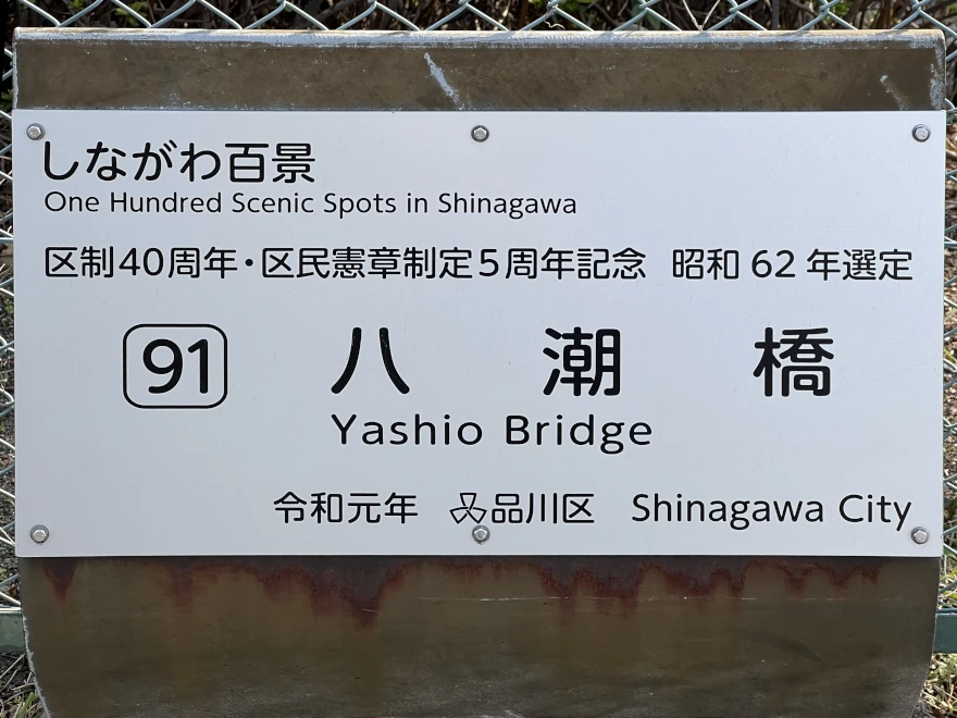
The Hyakkei sign is next to the fence on the eastern Yashio side of the bridge.
Withervee says…
It’s just a bridge, so what can you say? But honestly, the views are pretty nice. Look east or northeast and you can spot the Rainbow Bridge in the distance. To the west and southwest, you’ll see the warehouses along the Keihin Canal and the Yashio housing complex.
Crossing from the Shinagawa Seaside side means climbing 73 steps or taking a long, gentle slope. There’s an elevator, though. From the Yashio side, it’s just the slope. If you think of it as exercise, that’s not such a bad thing.
Once you cross over to Yashio, you can stroll along Keihin Canal Park;a popular spot for walks and fishing. A good spot to see the monorail running and the occasional and boat gliding.
Walking all the way to Shinagawa makes for a solid workout. The canal was once the heart of sea transport but has since been overtaken by land transport, now mainly used for tourism. Still, seeing the canal reminds you how Tokyo is truly a city of water.
The monorail zipping by, cormorants, gulls and small birds chirping – it’s a lovely place for a stroll.
Site Character
- Lifestyle 生活 (Seikatsu): ✔️
- Historical Significance 歴史 (Rekishi): ❌
- Atmosphere/Natural Features 風土 (Fūdo): ✔️
Who in their right mind would vote for this?
- Fans of industrial aesthetics
- People who enjoy big skies with sea breezes
- Amateur photographers
- Residents of Yashio Danchi
- Spiral staircase lovers
Further reading
City of Shinagawa: Keihin Canal Area
While you’re there…
Continue east to Yashio Danchi for sunset viewing or take the canal path north to Tennozu Isle.
Previous
90: Minatogaoka Futo Koen Park